Available for Q2 2026 engagements · Polito + freelance
Geospatial & GIS systems,
Geospatial & GIS systems,
built as products.
I’m M. Daud Tasleem - a civil-engineer-turned-geospatial product engineer researching at Politecnico di Torino. I build WebGIS, spatial-analysis pipelines, QGIS/Python tooling, GeoAI, remote sensing, and digital-twin systems - across infrastructure, urban analytics, and natural-hazard resilience.
110+ citations 7 peer-reviewed papers research at Politecnico di Torino

M. Daud Tasleem
Research Assistant · Polito · MSc Civil Eng (103/110)
Project reach · live globe
7 cities
TORINO · IT
45.07°N · 7.69°E
Research hub
Client delivery
01 The person
From civil engineer to geospatial researcher & builder.
I bridge academic rigor with product craft. Research at Politecnico di Torino feeds directly into the tools, plugins, and dashboards I ship.
Trusted by
- WHO World Health Organization Geo-data delivery · 2024
- PT Politecnico di Torino Research Assistant · DIATI
- DS DigiSky Italy ESA InCubed partner
- N NODES PNRR research grant
- M5 MANAGE 5.0 EU-funded consortium
- NU NUST · MCE Pakistan · BE alumnus
- ★ Upwork 3-year Top-Rated · 550+ jobs
Researcher at Politecnico di Torino and freelance geospatial product engineer with 550+ delivered projects.
My work turns messy spatial data into operational decision surfaces - combining WebGIS, spatial analysis, QGIS/Python tooling, GeoAI, UAV inspection, remote sensing, and digital twins in one coherent toolkit. I apply it across infrastructure and urban analytics, with a research focus on natural-hazard science - flood, landslide, urban heat, and seismic deformation.
On the research side I’ve published in Sustainability (MDPI), Scientific Reports (Nature), and Smart Cities. On the applied side, I’ve been a 3-year top-rated seller on Upwork, serving clients including the WHO.
I’m also an active open-source contributor - shipping QGIS plugins, Mapbox helpers, and small geospatial utilities to the community, and using them as the foundation for client deliveries.
550+Freelance projects
7Publications
110+Citations
OSSQGIS · Mapbox · GIS utils
02 The research
Funded geospatial research across hazards & resilience.
Six active and completed projects backed by MANAGE 5.0, NODES, and ESA InCubed - spanning multi-hazard analysis, urban heat and regreening analytics, corridor GeoAI, and digital-twin resilience.
Oct 2023 - Current
Funded · MANAGE 5.0
GIS-BIM 5.0 Web Visualization Platform
Unified platform for dynamic 3D data display and real-time urban analysis. Uses ML, Web-BIM, GIS, IoT, and GeoAI for 3D+ visualization and natural-hazard decision support.
Jul - Sept 2023
Funded · ESA InCubed
PCA for Urban Heat Vulnerability Index
Led Urban Heat Island study bridging academic + commercial sectors. Acquired and pre-processed thermal camera data with meteorological corrections; ran PCA on adaptive-capacity indicators and implemented green-infrastructure recommendations.
Feb - Sept 2023
Funded · NODES
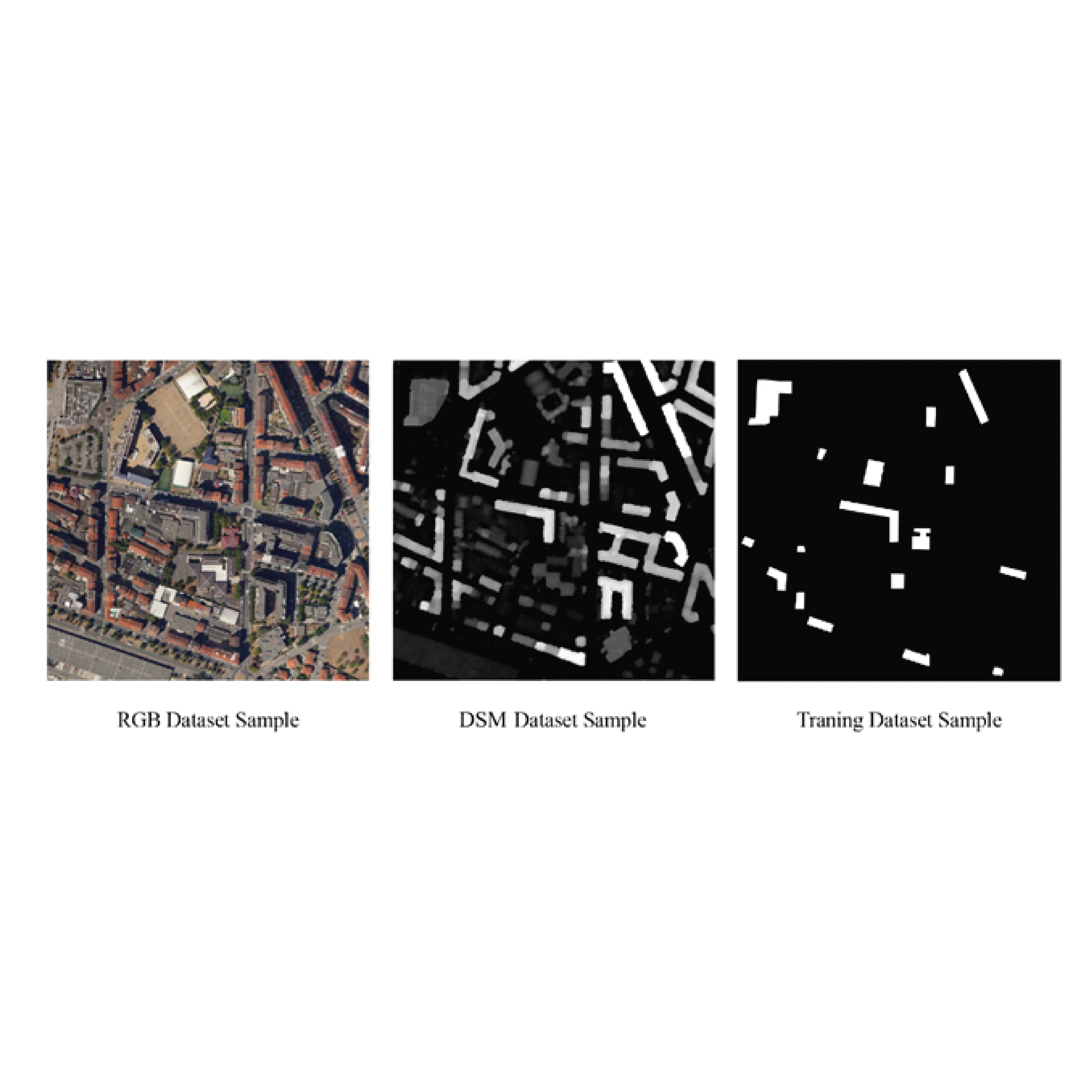
Multi-Hazard Landscape Digital Twin
Multi-hazard road-network analysis of Orco Valley with socio-economic indicators. Built a PostGIS database integrating 2D-3D open-source data and published in Q1 journal (Sustainability, MDPI).
Sept 2022 - Mar 2023
Sponsored Thesis
Corridor Mapping with Machine Learning
Pixel & object-based classification benchmark on 2D vs 2.5D datasets for airport corridors. Compared RF, SVM, DeepLabv3, SAM, and UNet - achieving 91% F1.
Aug - Oct 2022
Curricular Internship
Semi-Automatic Flat-Roof Extraction
QGIS plugin with a semi-automatic algorithm extracting green-roof / flat-roof data from dense urban ortho-mosaics - targeting urban-heat-island mitigation. Ground-truth accuracy: 92%.
Sept - Dec 2022
Fellowship
Giovanni Curioni’s 3D VR Museum
Immersive, interactive VR museum built in Unreal Engine 5. Cross-platform app providing access to high-quality 3D models of historical collections.
03 The papers
What’s been peer-reviewed.
Seven publications in Sustainability, Scientific Reports, and Smart Cities - 110+ citations, h-index 3, i10 3.
Metrics from Google Scholar, as of June 2026.
-
01
Sustainability · MDPI · 2024 · 45 citations
Comprehensive Analysis of the Use of Web-GIS for Natural Hazard Management: A Systematic Review
-
02
Scientific Reports · Nature · 2024 · 35 citations
Revolutionizing Urban Mapping: Deep Learning and Data Fusion Strategies for Accurate Building Footprint Segmentation
-
03
Sustainability · MDPI · 2023 · 27 citations
Enhancing Risk Analysis toward a Landscape Digital Twin Framework: A Multi-Hazard Approach in the Context of a Socio-Economic Perspective
-
04
Smart Cities · MDPI · 2025 · 3 citations
Spatial Insights for Building Resilience: The Territorial Risk Management & Analysis Across Scale Framework
-
05
Sustainability · MDPI · 2026
Rethinking Education on Critical Infrastructure Resilience and Risk Management
-
06
geodaysIT · Bari · 2023
The Use of Open-Source Machine Learning Techniques for Urban Features Extraction
-
07
Politecnico di Torino · 2023 · Master Thesis
Corridor Mapping Processing Using the Machine Learning Approach
GeoAI · Scientific Reports (Nature)
From ortho imagery to building footprints.
A DeepLabv3 model with RGB + height (DSM) fusion, extracting building footprints from very-high-resolution imagery. Drag to compare the input against the model’s prediction.
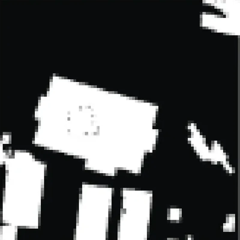
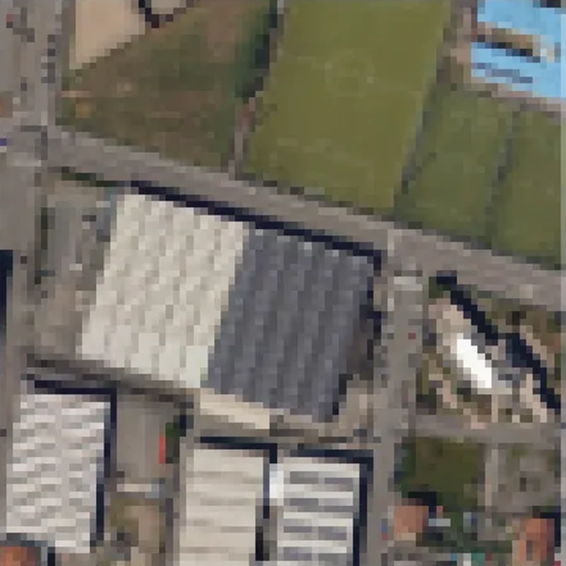
Input ortho
Predicted footprints
04 The lab
Click through the work like a product.
Pick a system - the preview, problem, outcome, and stack update live.
 Shipped surface
Rail monitoring / Digital twin
ModelRAIL Pro
Rail infrastructure monitoring with GIS, InSAR, UAV workflows, point-cloud review, digital twin views, audit logging, reports, and live operational context.
Node.jsCesiumMapboxInSAR
05 The method
From muddy data to a reviewable decision surface.
Every engagement follows the same four-beat loop. Hover a node to see what it actually means on the ground.
-
01
Discover
Map the hazard, the stakeholder, and the decision. Audit the data you actually have - DEM, SAR stacks, orthos, BIM, IoT feeds, ground-truth.
- Stakeholder interviews
- Data inventory & gap analysis
- Decision-surface sketch
-
02
Model
Build the analytical spine - PCA vulnerability, PSI/SBAS deformation, segmentation networks, multi-hazard PostGIS schemas - with reproducible notebooks.
- Geoprocessing pipelines
- GeoAI training & benchmarks
- Validation vs ground-truth
-
03
Interface
Wrap the model in a surface someone can actually defend in a meeting - WebGIS, plugin dialog, digital-twin viewer, or dashboard with real filters.
- Mapbox / Cesium / QGIS UI
- Accessibility & review flow
- Export / report generator
-
04
Evidence
Ship an audit-ready bundle - screenshots, data dictionaries, versioned notebooks, and a short Loom walkthrough. Nothing lives in a lone laptop.
- Evidence manifest
- Handover & training
- Post-delivery review
“M. Daud Tasleem’s work bridges academic rigor and ship-ready product craft in a way most geospatial engineers never reach. The digital-twin prototype was usable in the same week we briefed it.”
06 The work
Shipped systems & client deliveries.
Seven verified client deliveries - published research, WebGIS tooling, dashboards, plugins, and hazard analytics. Click a card to open the case-study gallery.
Published · Scientific Reports (Nature)
Urban building-footprint segmentation
DeepLabv3 + U-Net + RGB+Z fusion for high-resolution ortho-imagery. Five architectures benchmarked, camera-ready figures, co-authored journal paper.
- 5models benched
- RGB+Zdata fusion
- 15case images
Mapbox GL · WebGIS
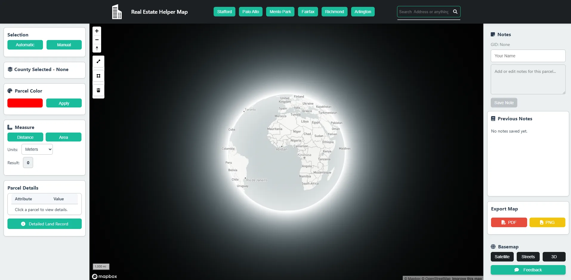
Mapbox real-estate parcel WebGIS
Browser-native parcel review surface - custom basemap, polygon-draw selection, attribute filters, and CSV / KML export for a real-estate client.
- Polygondraw selection
- CSV+KMLexports
- 2case images

PowerBI · Market study
Jacksonville FL MSA dashboard
Eight-page PowerBI report for the Jacksonville Metropolitan Statistical Area - spatial joins, demographic overlays, and KPI rollups for a US market-study client.
- 8report pages
- Spatialjoins
- MSAscoped
QGIS · Client plugin
Cross-border highway SPO plugin
PyQGIS plugin enforcing EU cross-border highway Special Planning Object guidelines - geometry validation, topology checks, and audit-ready report export.
- Autogeometry check
- PDFreport export
- EUguideline ref
Published · Sustainability (MDPI)
Multi-hazard risk assessment
Multi-hazard susceptibility, exposure, and vulnerability modelling - flood, landslide, seismic - synthesised into a risk index for sustainable infrastructure planning.
- 3hazards modelled
- PCArisk index
- 9figure pages
Urban climate · UHI
Urban Heat Island vulnerability
LST, NDVI, and adaptive-capacity analysis for an urban heat-island study summary - Landsat-derived rasters, PCA-driven vulnerability index, and map deliverables.
- Landsat 8LST rasters
- PCAadaptive index
- 6case pages
Hydrology · 44-page report
Watershed hydrology & morphometry
DEM-driven watershed delineation, morphometric indices, and hydrological response modelling - packaged as a 44-page audit-ready engineering report.
- 12morphometric idx
- 44page report
- 12case pages
07 The tools
Small geospatial utilities, free to run.
Current GIS Tools Lab inventory: 13 active tools and 1 planned utility for dataset discovery, point clouds, topology, network simplification, BIM meshing, ecosystem restoration, UAV inspection, spatial QA, and raster attribute tables. Verified against GitHub repositories on May 29, 2026.
v0.1.0
netsimplify
Topology-preserving simplification for geospatial infrastructure line networks. Pins shared vertices (junctions, T-junctions) so network connectivity is never broken — unlike geopandas.simplify() or ST_SimplifyPreserveTopology.
v0.1.0
raster-attr
Read and write Raster Attribute Tables (RATs) across three backends: GeoTIFF internal TIFF PAM (GDAL), .aux.xml PAM sidecar (lxml), and .vat.dbf dBASE III sidecar. Unified API with pandas interop and a CLI.
v0.1.0
cog-focal
Ghost-buffered tile streaming for focal raster operations on Cloud-Optimized GeoTIFFs. Computes slope, aspect, hillshade, focal mean, and focal std with zero seam artifacts at tile boundaries. Pure NumPy + rasterio.
v0.1.0
restoration-zonal-diff
Streaming Monte Carlo zonal-diff over a baseline land-cover raster and restoration scenario rasters, with per-zone delta-ESV and 95% credible intervals in a single raster sweep — targeting urban green-infrastructure and nature-based solution planning.
v0.2.0
line-noder
Detects all interior line-line intersections in a polyline collection and builds a fully planar edge-node graph. v0.2 adds a Shapely STRtree backend for a 2.5× speedup on 20k-segment sparse networks; the pure-NumPy pairwise backend remains the default on small inputs.
Live demo
GeoBrief
Reads GIS datasets, infers semantic metadata, proposes useful spatial questions, and checks whether a custom question is answerable with the available fields.
v0.1.0
laz-tile-index
Explores portable JSON sidecar indexes for LAS/LAZ point clouds, previews bbox query windows, and shows which grid cells a query would read.
v0.1.0
lidar-strip-adjust
Automated boresight calibration and strip adjustment for airborne and UAV LiDAR point clouds. Planar-neighbourhood ICP with Levenberg-Marquardt optimisation, CLI and Python API.
v0.1.0
aerial-lidar-spatial-eval
Distance-weighted, spatially-aware evaluation metrics for aerial LiDAR semantic segmentation. Computes boundary-aware IoU and hard-point detection, running scipy KD-tree computation in the browser.
v0.1.0
ifc-slab-mesh
Constrained Delaunay triangulation of IFC slab footprints with opening subtraction. Parses IfcSlab and IfcOpeningElement via ifcopenshell, meshes with Shewchuk's Triangle, and exports OBJ / PLY / NPZ. 201,810 triangles/s over 200 slabs.
v0.1.0
rs-patch-sampler
Nodata-aware, geographically-stratified patch sampler for satellite raster imagery. Rejects nodata-heavy patches via windowed reads, maximises spatial spread with greedy farthest-point selection, and supports class stratification via label rasters.
v0.1.0
topo-coverage-simplify
Topology-safe simplification of polygon coverage layers. Detects shared boundary arcs via STRtree, simplifies each arc once (Douglas-Peucker), and reconstructs both neighbours identically — no gaps or slivers introduced. Zoom-aware tolerances via a pixel-error model for web-map tile pipelines.
Live demo
gisgap-uav-structure
Multi-modal UAV structural inspection pipeline visualizer. Fuses six sensor streams — RGB, thermal, LiDAR, GPR, acoustic, and X-ray backscatter — through an ML defect-detection pipeline for cracks, corrosion, and delamination. Risk progression modelled with neural ODEs and Bayesian state-space models.
Planned
SpatialLint
Dataset quality checks for CRS, geometry validity, suspicious coordinates, missing context, and publication readiness.
Coming next08 The stack
Map, model, interface, evidence.
09 The engagements
What you can hire me to build.
Three packaged ways to work together. Each ships an audit-ready bundle — source, data dictionary, and a short walkthrough — not a one-off file on a laptop.
Across funded research & client work
Politecnico di Torino
ESA InCubed
NODES · EU
MANAGE 5.0
WHO · MENA
WebGIS products & dashboards
Map-first interfaces a stakeholder can actually defend in a meeting — built on Mapbox GL, Cesium, or Leaflet over a PostGIS backend.
- Interactive layers, real filters & search
- Auth, exports, and report generation
- Responsive, accessible, review-ready UI
GIS tooling & automation
Turn a repetitive spatial workflow into a button. QGIS/PyQGIS plugins, Python geoprocessing pipelines, and spatial QA you can re-run.
- QGIS plugins & PyQGIS processing scripts
- GDAL / GeoPandas / FME pipelines
- Reproducible notebooks & validation
GeoAI & remote sensing
Pull signal out of imagery and radar. Segmentation, ground-deformation, and change detection — benchmarked against ground-truth.
- DeepLabv3 / U-Net segmentation
- SAR/InSAR (PSI · SBAS) deformation
- Sentinel-1/2 fusion & change detection
550+ projects delivered
3-yr Top-Rated on Upwork
WHO · ESA · EU-funded clients
7 peer-reviewed papers
Start a project
10 The collaboration
Need a geospatial system that feels real enough to review?
Best fit: WebGIS products, spatial-analysis and GIS tooling, GeoAI demos, remote-sensing (SAR/InSAR) workflows, QGIS/Python plugins, digital-twin prototypes, and natural-hazard platforms.
- WebGIS products on Mapbox GL, Cesium, or ArcGIS JS
- Natural-hazard platforms (flood, landslide, seismic, UHI)
- SAR / InSAR workflows - Sentinel-1, PSI, SBAS
- GeoAI segmentation & corridor classification
- QGIS / PyQGIS plugins & scripted geoprocessing
- Digital-twin prototypes with BIM + GIS